")


The azimuths determined in the interests of civil and military users. For each complex technical system the individual requirements for the accuracy and timeliness of the determination of azimuths demands. These standards are due to operation rules. In addition to the requirements there are a number of specific, individual standards due to the special conditions of application of the technical system, the most important requirement is an "autonomy".
By "autonomy" we mean such characteristic method of definition of geodetic data, which allows you to get them indepently of weather conditions, without a source of a geodetic basis, at any time of the day.
The requirement of the autonomy orientation method arises in providing geodetic data mobile technical systems, especially when applying them unprepared in advance in respect of geodesic districts. Also, the requirement of autonomy orientation method occurs when geodetic surveys for construction and geodetic support facilities located in areas with large sparse geodetic network or in extreme climatic conditions (laying of pipelines, communication and powerlines).
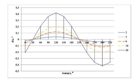
Determination of the azimuth using method of space geodesy is not described in the manuals and technical guidance. Principally there ara describing without obtaining estimates of the precision of the azimuth receive only a relative method of space geodesy in the "Technical guidance on development of special geodetic networks relative method of space geodesy". Offered in the scientific literature azimuth definition with the usage of relative method of space geodesy using the original geodetic network allows us to make an orientation root mean square error up to 0.5 arcsecond [1].
In connection with the possibilities for high-precision definition of the increments and equal influence in the same moment of time different sources of errors on measurement results for any receiver in the local area (10-30 km), the research capabilities were conducted with operational Autonomous orientation with the application of higer geodesy. The result of this research was to study the possibility of Autonomous operational orientation with high accuracy with the usage of satellite geodesy method without using the original geodetic framework.